A history of the garden site itself and the entire block—Block 439 on OASIS Map. The garden is situated in Lot 10 which is also occupied by the school’s playground and soccer pitch.
- Along 1st Avenue (referencing the above OASIS Map):
- Building in lot 1 (the mosque), was built in 1910.
- Buildings from lot 2 – lot 9, were built in 1900 (estimated).
The cemetery’s stone wall (originally built in 1867) which still partially exists, separated the cemetery from all of the buildings that lined along 1st Ave.
The 10/3/2018 fire occurred in the building in lot 4 (188 1st Ave).
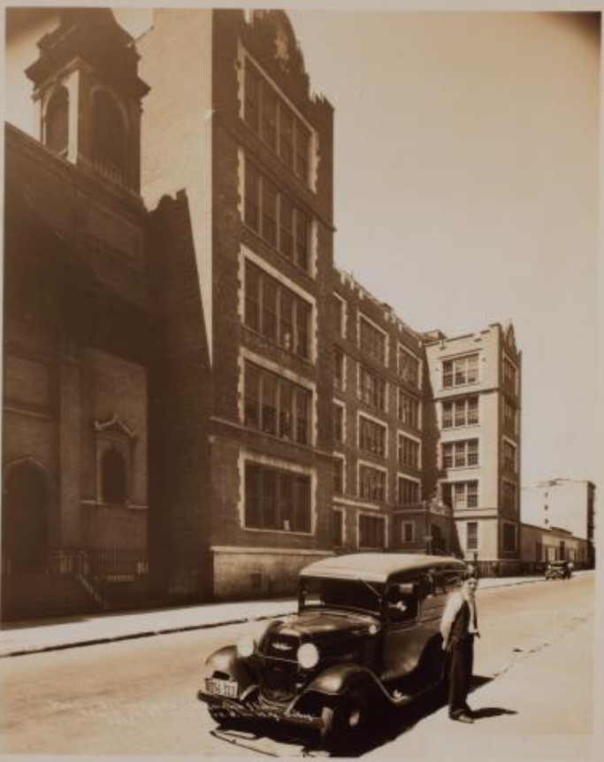
- School building, lot 17, built in 1920.
- Lots 28 and 30, buildings on the northeast corner of the block (12th St & Ave A) were built in 1900 (estimated).
- Lot 7501, new condominium and retail space, built 2017 (this lot used to be occupied by a Roman Catholic church, Mary Help of Christians (built 1917/1918), a parochial school (1925), and the church’s parking lot which hosted a flea market).

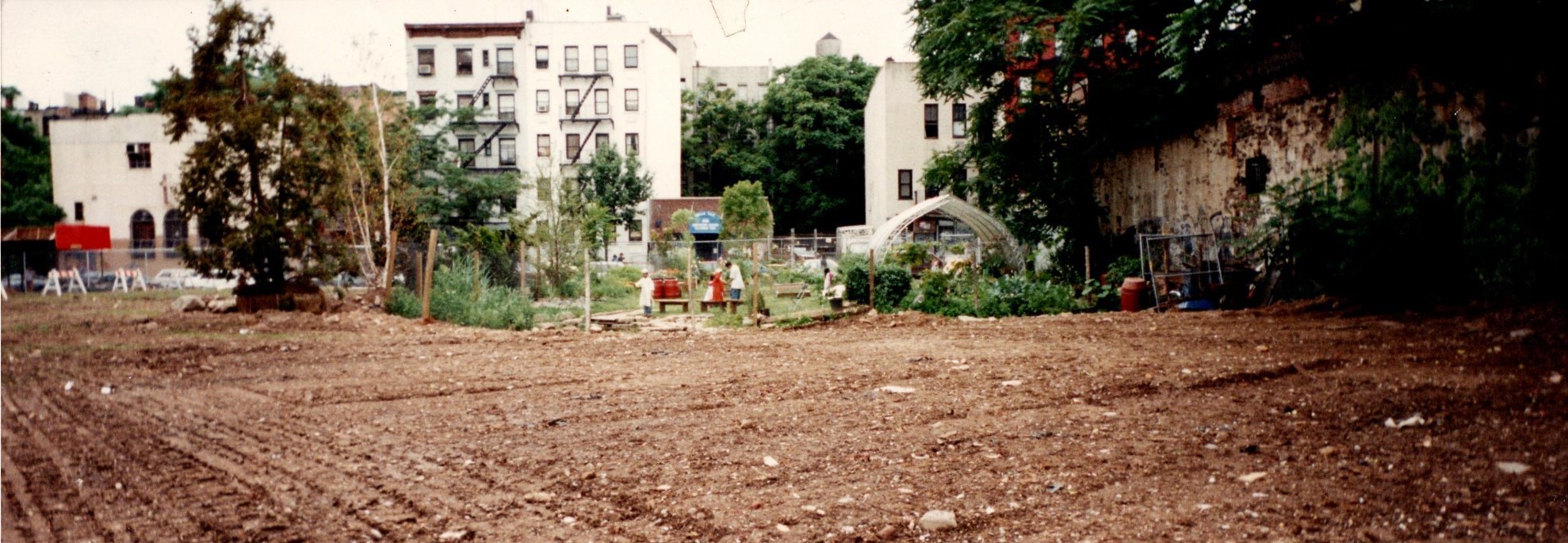
Lot 10, photo taken 1987 or 1988 (after bus depot demolished in 1987).
Source: NYC Dept of Records & Information Services, nycma.lunaimaging.com/…
Plant species and terrain in the Year 1609
Links via the OASIS Map link above:
- See what the area probably looked like back in 1609 (Mannahatta Project): 11th St & 12th St between Avenue A & 1st Ave.
- A comprehensive list of the probable plant species and animals of this area in 1609.
As a GreenThumb Community Garden
Soon after the bus depot was demolished (1987 – see Open Road Park below), people in the neighborhood started to convert the space into a community garden (1988). Within a few years, it became an official green space/park, and by 1996 became a GreenThumb garden, the first time around. The second time around was in 2016 after several personnel and activity changes and relations with other entities. The years leading up to 2016, people in the neighborhood did not have access to the garden and many wanted to get involved.
In 2016, the garden was reorganized to be a community garden again. GreenThumb gave us an orientation workshop and after completing the necessary requirements, people could once again get involved.
The students at the school next door (East Side Community High School) came up with the new name for the revived community garden, East Side Outside Community Garden.
Collaboration Activities between ESCHS and the Garden/Composting Groups
(For a period until 2016, the garden was not open to the public, but various volunteers participated in composting and other projects, with and separately from the school.)
…
See also our section on ESCHS.
Open Road Park
Also known as LES Park (Lower East Side Park)
Information gathered from files stored in the greenhouse at the garden by Amy Anthony.
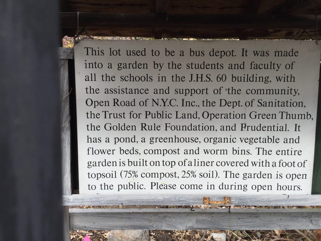
- The site was formerly a bus depot that was demolished in 1987. It was contaminated and needed to be remediated (petroleum and lead were 10-14 feet below the surface).
- LES Park development started by Open Road in 1990/1991 in cooperation with ESCHS and The Learning Project.
- Open Road received funding from the Dept of Sanitation to cap the contaminated soil with a landfill liner and purchase gravel and soil.
- Open Road secured a GreenThumb lease in 1996.
- LES Park became a part of the Trust for Public Land in 1997; LES land jurisdiction rests with the Board of Education.
- It seems that there was a film set of a garden installed for 1.5 weeks on the property and the film company gave the garden (Open Road) all trees and plants and donated 6,000 sq ft more of liner to expand the garden to 12th street. (Year?)
- Open Road staff changes happened in early 1999. Further information could not be found in the files in the greenhouse beyond that point in time.
Further information, including cemetery and Parks history with the site: https://en.wikipedia.org/wiki/Open_Road_Park
Bus Depot and Garage
A one-story story structure was built in 1919 (demolished 1987). See photo below taken in 1920.
Cemetery Extension
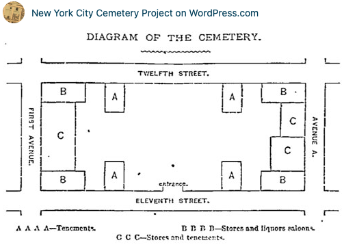
Source: New York City Cemetery Project, 11th Street Catholic Cemetery, 11/14/2010.
From 1833, most of the block (from 1st Ave to behind the row of buildings along Ave A, at that time) served as a cemetery, the 11th Street Catholic Cemetery, for the city’s catholic community. The church was at a different location—the cemetery opened after St. Patrick’s Old Cathedral’s (today, The Basilica of St. Patrick’s Old Cathedral at 263 Mulberry St, along Price St and Mott St behind the church) burial grounds reached capacity. By 1848, the 11th Street Catholic Cemetery (1 mile away from the church) also reached capacity and new burials went to Queens, the Calvary Cemetery. The church tried to sell the property from 1883 and finally succeeding in 1912, after several oppositions. Only a fraction of the graves were moved to Calvary Cemetery in 1909 (only 3,000 to 5,000 of the 41,000+).
(New York Herald 1883)